One of the most powerful aspects of the map is the connection to Google Street View. Even if you cannot visit a location in person, you can still ‘walk around’ in Street View, viewing the houses and getting a feel for how the area looks today.
Each place marker is annotated with the name and dates of the individual, when they were resident, today’s address and (if different) the address at the time they moved in, and notes such as whether there is a memorial plaque. Concise biographies of the featured individuals are available by following the links to Wikipedia and the Oxford Dictionary of National Biography (ODNB). ODNB is behind a paywall, but you can use it for free by signing in with a Camden or City of London library card number. Some entries have an additional reference, which may be a link to an online document or the name of a publication.
Web browser
The map can be viewed in a recent web browser, such as Chrome, Safari or Edge:
- The legend (side bar) shows the list of categories. Each category can be expanded to show a list of names. Place markers for the complete category can be displayed or hidden using the corresponding checkbox.
- A name may appear more than once if the individual lived at different addresses in Camden.
- A button at the bottom left of the legend can be used to switch the background between outline map and satellite image
- A place marker can be selected by clicking on it in the map or by clicking on a name in the legend. Place markers in the middle of a road or square indicate that the precise location is uncertain.
- When a place marker is selected, the legend changes to information about the person and the location.
- To view the location in Street View, click on the directions icon at the top right of the legend to load the selected place marker into Google Maps in a new tab.
- When no place marker is selected, click on the search icon at the top of the legend to search the annotations by name or keyword
- The map contains several thousand place markers, which can slow down scrolling and zooming operations on a tablet or phone. Responsiveness can be improved by de-selecting all categories except the one of interest. Or, switch to the Google Maps App, which will usually be faster.
Google Maps App on Android
If you have the Google Maps App installed, this becomes the default map viewer. If you prefer to view the map in a web browser tab, touch and hold the link and select Open in new tab.
When opened in the Google Maps App, the following features are available:
- The legend, which shows the list of categories, is displayed at the bottom of the screen when the device is vertical and at the side of the screen when the device is horizontal. Place markers for a complete category can be displayed or hidden using the checkboxes. If the legend is full-screen, use the back arrow
 to return to the map.
 - A place marker can be selected by tapping it. Place markers in the middle of a road or square indicate that the precise location is uncertain.
- When a place marker is selected, information about the person and the location is displayed in the legend.
- When no place marker is selected, the layers button
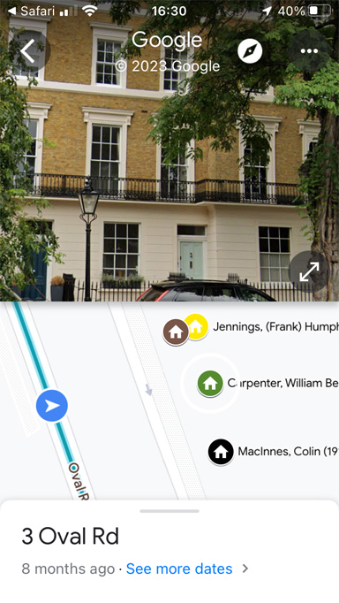
 can be used to switch the background between map and satellite image and to enable or disable Street View
 - When Street View is enabled, tap on any blue line to enter Street View. Tap the split-screen arrows
 to toggle between a full-screen Street View image and a split-screen view that displays both image and map. Use the back arrow to close Street View.
 - To remove all Camden Notables place markers and revert to the default Google Maps display, tap View Map Legend, then tap close
 .
.
Google Maps App on iOS (iPad or iPhone)
In many respects, the Google Maps App behaves very similarly on iOS and Android. Unfortunately, the iOS version has some limitations:
- There are issues with scrolling the legend, so that some of the information fields are not visible
- Links to Wikipedia and ODNB are rendered as plain text and are not clickable
- Whether or not a particular Place Marker is displayed depends on the zoom level
To remove all Camden Notables place markers and revert to the default Google Maps display, tap View Map Legend, then tap close ![]() .
.
NOTE: If the View Map Legend link goes missing, the work-around is to tap on an empty area of the map, choose Saved from the pop-up menu, then Maps. Tap Camden Notables to reload the map and the View Map Legend link will be restored, allowing you to get to the close button.
The Google Maps App is faster than a web browser and provides better integration with Street View. But, if you want to read the annotations or follow the links to Wikipedia and ODNB, it may be better to view the map in Safari or Chrome. To switch between Google Maps and a web browser, when opening the map, touch and hold the link and select either Open in new tab or Open in Google Maps.